The Meigs Line
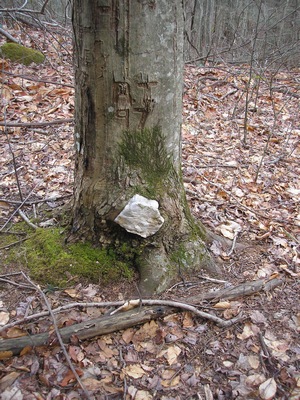
As I mentioned to you last week, I received an interesting comment about our bushwhacking adventure off the Bent Arm from Dan Welch. Subsequent correspondence revealed the following information and I appreciate Dan sharing this with the Highlander crew. We made this trip in February, 2008 http://www.southernhighlanders.com/BentArm.htm when we hooked up with the Muir Faction at Miry Ridge. A random photograph prompted the discussion and I have included Dan's comments on the matter below. It is an interesting read. It began with this comment from Dan. "Do you realize that the quartz rock at the base of the tree in your Bent Arm hike photograph is a boundary marker on the Hawkins line placed by Cherokee members of the RJ Meigs survey party in 1802? This photograph is a great prize"
First correspondence:
The identity of this Cherokee Boundary marker is
reveiled in a very recent (2009) book by Dwight McCarter and Joe Kelly titled "Meigs
Line." Although the survey crew with RJ Meigs is believed to have placed the
quartz marker in 1802 the acutal line under survey is still known as the
"Hawkins Line." As the book reports for a very short time the "Hawkins Line"
was the southern most legal settlement boundary of the southwest United States.
The location of the "Hawkins Line" as well as other surveys inside the
boundaries of the present GSM National Park have long been lost - some reports
of lost predate the Civil War. The "Hawkins Line" had a major impact upon
settlement in early Blount County - let alone Cades Cove. Although small pieces
of the "Hawkins Line" had been discovered over the years, not until the new "Meigs
Line" book has it been shown that a vast array of 200 year old original survey
marks inside and outside the Park can still be discovered on the ground - many
in very out of the way locations.
The "Meigs Line" book describes the quartz marker on the old Bent Arm trail but
does not provide a photograph. But the book does discuss the significance of
using quartz. Many other Cherokee marker techniques are discussed in the book
as well - some of these marker techniques were used in other locations. Overall
the "Meigs Line" book should be of high facination to your hiking friends as it
descibes many unique locations that can be found inside the Park backed with
historical details. If I understand your hiking friends well - most will not be
able to put "Meigs Line" down until totally read and it will be likely they
carry the book as well as its fresh knowledge into the field. I'm certain there
is still much yet to learn about the Smokies and very few that will protect its
treasures.
Dan
Second correspondence below:
I can speculate that the quartz rock is in a
beech. If so, it is a rather large beech tree considering the elevation and its
location very near the Bent Arm Ridge. I can easily imagine such a tree being
200 years old. However, I would believe it tiny in 1800. So there is some
mystery. This mystery merits expert attention. This is no ordinary discovery -
it should be of interest to scholars.
There is a little bit to be discovered on the internet about the location of "Meigs
Line" and the master survey marker called Meigs Post on Mount Collins.
Apparently there was court battle between lumber companies in the 1890s (before
the formation of the Little River Lumber Company) involving the location of the
"Hawkins Line" and thus Meigs Post. It was during this court contest that
Wilson Falls was named for a surveyor hired to help resolve the controversy.
Maybe the quartz rock was reset at that time. Information is so slim it is
difficult to learn if any other features on the upper reaches of Little River
are named after surveyors.
By the way. Meigs Post is the master survey marker for not only "Hawkins Line"
but also "Pickens Line," "Butlers Line," and "Meigs Line." There are dozens of
these ancient survey marks to be discovered inside the Park on the North
Carolina side as well - some in very rough terrain well removed from any
trails. Meigs Post is atop Mount Collins very near the junction of the
Appalachain Trail and the Sugarloaf Trail. According to the book it is easiest
to discover the ancient marker trees that surround the now tiny Meigs Post
first. One can start at Meigs Post and simply follow a compass.
Many thanks to Dan for sharing his historical knowledge. Many of us appreciate the education and intend to scout the notion further.
John